↓
 

Charlotte Land Surveyor

...a Pro17 Engineering marketing website.

Charlotte Land Surveyor
  • Home
  • ALTA Survey
  • Boundary Surveying
  • Construction Survey
  • Elevation Certificate
  • Land Surveying
  • Lot Survey – Closing Survey
  • Topographic Survey
  • Contact Us
Home - Page 2 << 1 2 3 4 5 6 >>

Post navigation

← Older posts
Newer posts →

Can Engineering Flood Study Help Your Neighborhood?

Can an Engineering Flood Study Help Your Neighborhood?

flood zone | flood surveyA recent article in the Allied News in Grove City, Pennsylvania reminded me of the Engineering Flood Studies that I have completed over the years and how these have helped the neighborhoods adjacent to the streams that were studied.

“FEMA says it does allow the municipalities to pay for their own engineering study to prove that areas along Wolf Creek are no longer affected by flooding since dams were taken out.”

Not only are flood studies useful when conditions change, like a dam being taken out, but for the following conditions:

  • A stream has never had a detailed flood study completed (called Zone “A”)
  • Contemplation of widening a ditch to handle the flood waters within it
  • Proving that a stream Base Flood Elevation (BFE) and flood hazard zone are incorrectly shown

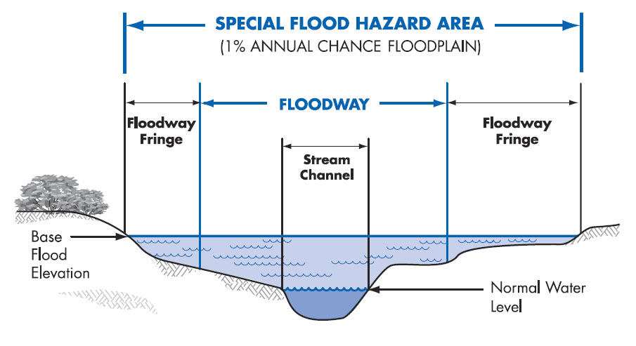
Every Stream Has a Base Flood Elevation

The fact about flood zones that most people don’t realize is that EVERY stream has an elevation that it will rise to given a certain amount of rainfall. The more rainfall, the higher flood waters will rise. So, when an area receives the 1% chance storm (formerly called the 100-year storm), you will see the flood waters rise to a level called the Base Flood Elevation (BFE). And, again, every stream has a Base Flood Elevation.

So, if you live by a dry ditch, an intermittent stream, or a year-round flowing creek, you should be aware of the Base Flood Elevation of that stream. So, FEMA doesn’t “PUT” you in a flood zone. They only map the flood hazard of more and more streams each time, and “SHOW” you in the flood zone that you were already in. There are also instances where development has occurred since the previous flood maps were created and your area has experienced an increase in the flood elevation because of the change in the amount and speed of the runoff.

Estimated Flood Zone “A”

The most common areas that are in need of a flood study are those estimated flood zone “A” areas on the flood maps. This means that a “detailed study” hasn’t been done for that area and the flood zone is estimated based on contour maps of the area. It is difficult for insurance companies and surveyors to determine your risk in these areas because we don’t have an elevation to use to compare to your home elevation.

The steps for an Engineered Flood Study are:

  1. Determine the length of the stream to study. This can be 500 to 5000 feet or more.
  2. Collect cross-sections of the stream. This gives the shape of the stream bed which tells us how much water can move through the stream and how far outside the banks the flood water will come.
  3. Determine the drainage area for the stream. This is done using contour maps of the area.
  4. Estimate the runoff coefficients for the drainage basin. This is not easy to accurately estimate and this step is where lots of variance is built into the equations.
  5. Use the data collected and an approved method and software program to determine the base flood elevation.
  6. Submit the findings to FEMA for concurrence and approval.

As I said in one of the steps, drainage calculations are only estimates. All of the approved methods and formula have a certain amount of variance in them. Most methods are from 65% to 85% accurate. This is based on the many types of soil, vegetation, and ground cover that occurs within the drainage basin, and the estimates used in the amount of rainfall and runoff that occurs.

flood survey | flood study | flood zoneThis is why most flood ordinances require that new homes are built at least one to two feet above the BFE. And, it’s the reason that I always recommend that you get flood insurance if you are close to a stream, even if you are shown as being OUT of the flood hazard zone. The insurance policy is cheapest in that situation. And, flooding over the 1% storm happens all the time. Consider it similar to your homeowners insurance which covers fire damage.

References: Trends in Floods,  and The Human Impact of Floods

If you have questions about a flood study, or any other flood elevation questions, call Charlotte Land Surveyors at (704) 285-1222.

Posted on September 25, 2017 by Charlotte SurveyorFebruary 21, 2020

The Basics of Land Surveying

Charlotte Land Surveyor Posted on August 11, 2017 by Charlotte SurveyorFebruary 21, 2020

land surveying basics

What is Land Surveying?

Land Surveying dates back to ancient history. Surveying is used for multiple projects.  A survey is done to establish a specific location of a parcel of land along with its exact acreage.  It is used to ascertain boundaries for defining an area of ownership and tax liability.  It is also used to identify a piece of property by a written legal description or to provide a review of the accuracy of an existing description. Data from land surveying is of the utmost importance with regard to buying and selling land, and is also used to insure a clean and marketable title.

Other types of Land Surveying

There are many different kinds of surveys that can be performed. Boundary surveying is typically done for undeveloped land. This type of survey measures the actual physical extent of the property in question. Most surveys progress through the basic procedures regardless of the type being done. Any pertinent deeds, contracts, maps or other documents that contain a description of the property’s boundaries are located, studied and interpreted.

A determination is made of what the actual property description is deemed to be, along with the locations of any physical evidence of the boundaries. This can be in the form of both natural and man-made monuments or markers that exist in the field.

The property is then measured to establish the boundaries, not only using the appropriate existing monuments but with the creation and referencing of new markers where necessary. Measurements are accomplished using a total station and other land surveying tools. A total station measures both vertical and horizontal angles, as used in triangulation networks. After these steps are accomplished, the property description and plat are prepared.

Results of land surveying

Interpreting the results of a land survey is not as difficult as it may first seem. For instance, a property plat will usually contain a directional orientation which is typically indicated with an arrow pointing north. It will contain the bearing and distance of each boundary line, the property lines of other properties shown on the plat, and the names of adjacent property owners listed in the areas of their property.

Corner monuments, along with the names of any natural monuments (such as “Smith’s Creek”, for example) or a brief description of any unnamed natural monuments (such as the “30-inch pine tree”) are on the plat. There is also a title block containing the property’s location and name of owner, the surveyor’s name, the date the survey was performed, the scale of the plat and any other relevant data.

If you need the services of a surveyor for your land surveying needs, ALWAYS be sure that you’re hiring an experienced, certified, and highly competent professional surveyor. Call one of our land surveyors at (704) 285-1222 to discuss your needs.

Posted in boundary surveying, land surveying, land surveyor, property survey | Tagged boundary surveying, land survey, Land Surveying, land surveying importance

What Is A Land Surveyor?

Charlotte Land Surveyor Posted on July 28, 2017 by Charlotte SurveyorMarch 17, 2018

Land Surveyor

A Land Surveyor is essential whenever you plan on building a house, buying or selling a property, or dividing your property amongst your children. Many land surveyor made it down to history.

In fact, three of the four faces carved in Rushmore are land surveyors (Presidents George Washington, Thomas Jefferson and Abraham Lincoln were all three surveyors, Teddy Roosevelt was not.).

Others popular names were Daniel Boone, Meriwether Lewis and William Clark (Lewis & Clark), Sir George Everest, Charles Mason & Jeremiah Dixon (of the Mason-Dixon Line fame) and author Henry David Thoreau practiced for a time in Concord, Massachusetts.

What is a Land Surveyor?

Aland surveyoris a person with the academic qualifications and technical expertise to measure and plot the lengths and directions of boundary lines and the dimensions of any portion of the earth’s surface (including natural and other structures). That definition is quite a mouthful, but in actuality the field of surveying (geomatics) includes many other facets.

If you plan to purchase a lot, build your dream house, divide your property to your children, or simply want to know the details of a land property, a land surveyor is the best person to help you out. A land surveyor locates theboundaryof your property and the location of your home within that boundary to determine if there are any encroachments by your neighbors onto you or vice versa. Common encroachments are fences, driveways, etc.

These days a land surveyor in the United States is regulated and licensed by the various state governments. In North Carolina, the North Carolina State Board of Licensure for Professional Engineers and Land Surveyors was established in 1935 to protect the public.  A land surveyor’s duty is “to safeguard life, health, and property, and to promote the public welfare by providing for the licensing and regulation of persons in the practices of engineering and land surveying. This purpose is achieved through the establishment of minimum qualifications for entry into the professions of engineering and land surveying, through the adoption of rules defining and delineating unlawful or unethical conduct, and through swift and effective discipline for those individuals or entities who violate the applicable laws or rules.”

How to become a land surveyor?

As of 2007, a newly licensed land surveyor is required to finish a four year degree in surveying or a closely related field, a four to eight years of on-the-job training under a licensed practicing surveyor. In addition to that, licensed land surveyors are mandated to attend 15 hours of continuing education annually to ensure that they are kept updated with the new know-hows that would help them on their professional growth.

What does a land surveyor do?

As part of a standard lot or mortgage survey of a property, expect your land surveyor to review tax maps, aerial maps, deeds, subdivision plats, zoning ordinances, subdivision regulations and possibly even flood maps. For a typical lot survey, the subdivision plat is the most important of these because it tells the exact dimensions of your lot and the relative location of your property corners. The surveyor uses this to locate and/or re-establish your property corners.

In the field, a land surveyor will search for your property corners along with some of your neighbors’ corners. If yours can’t be found, they’ll measure the distances and angles between all of the points, locate the improvements on your property, including your house, pool, out-buildings, retaining walls, fences, driveways, sidewalks, and other home improvements. Other improvements like sanitary sewer mains, storm drainage ways, overhead power lines and the like are located because these might indicate an easement across the property. The plat should show these, but may not in all cases.>

Once all of the field information is gathered, the crew chief takes the field notes and prepares a preliminary sketch of the work. This is passed along to a draftsperson who prepares the final outline for your use. The draftsperson will check all of the maps mentioned earlier to make sure that all building setback lines and easements are shown on the draft. The surveyed distances and directions are compared to the plat distances and directions as well. Any discrepancies or encroachments are shown on the drawing. Your lawyer may use the draft to determine if any other legal work is needed during the closing. The mortgage company or the bank may also use the survey for their records.

So now, what do you have for your money. You have a drawing which shows your house on your lot. You should have stakes and/or flagging by all of your property corners. Make sure you know where they are located. The actual corner is marked by an iron pin or pipe of some sort. (The type of monument should be shown in your survey drawing.) You might also want to take a look at them at least once a year to make sure they’re still there. (Even animals mark their territory more often than that.)

Posted in boundary surveying, land surveying, land surveyor, property survey | Tagged boundary survey, land survey madison, land surveyor, what is a land surveyor

Post navigation

← Older posts
Newer posts →

Search This Site

CONTACT US

    Recent Posts

    • Welcome to Charlotte Land Surveyor
    • Surveying For Fence Contruction
    • Difference in FEMA Elevation Certificate and LOMA
    • Can Engineering Flood Study Help Your Neighborhood?
    • The Basics of Land Surveying
    © Copyright Charlotte Land Surveyor
    Charlotte, NC
    Phone:(704) 285-1222

    Privacy Policy | Terms of Use

    Web Development and SEO by:
    N2Biz.co

    Privacy Policy | Terms of Use

    ↑