
What a Topographic Survey Shows and When You Need One
A topographic survey doesn’t come up in most conversations until a project requires one. Then suddenly everyone involved needs one, and nobody is quite sure what it produces. If you’re a homeowner, a land buyer, or someone planning to build, this article explains what a topographic survey is, what it shows, and when you’d actually need one.
What a Topographic Survey Actually Produces
A boundary survey focuses on property lines. A topographic survey focuses on what the land itself looks like. The finished product is a detailed map. It shows elevation changes across the site, contour lines that reveal slopes and grades, and the locations of features already on the property.
Those features usually include:
- Trees and large vegetation
- Buildings, sheds, and retaining walls
- Utility poles, boxes, and surface access points
- Fences and walls
- Drainage channels, streams, and low spots
- Roads and paved areas
Everything gets plotted at specific elevations. That means whoever is designing the project knows exactly what’s on the ground and how the land rises and falls from one point to another.
The drawing looks two-dimensional, but it holds three-dimensional information. Every point on the map has an elevation attached to it. That’s what makes it useful for engineering and design.
How a Topographic Survey Differs From a Boundary Survey
These two surveys serve different purposes. A lot of people assume they do the same thing. They don’t.
A boundary survey answers one question: where does this property begin and end?
A topographic survey answers a different question: what does the land inside those boundaries actually look like?
Both can be done at the same time. But ordering one doesn’t give you the other. If you need confirmed property lines, that’s a boundary survey. If you need elevation and terrain data for a design project, that’s a topographic survey. Many projects end up needing both.
When a Topographic Survey Becomes Necessary
Not every property owner needs one. It usually comes up when a project involves changes to the land, or when a designer needs to understand the terrain before making decisions.
New construction on raw land. Before an architect or engineer designs a home on an undeveloped lot, they need to know what the land looks like. The topographic survey gives them elevation data to position the building, plan drainage, and avoid surprises once construction starts.
Home additions and site improvements. Adding a pool, a large deck, a garage, or a major grading project may require one. Engineers use the elevation data to make sure new structures drain properly and don’t push water toward the existing home or neighboring properties.
Land development and subdivision. Developers planning to build multiple structures or divide land almost always need a topographic survey. Civil engineers use it to design roads, drainage systems, utility layouts, and grading plans for the whole site.
Steep or uneven terrain. On lots with significant slopes, a topographic survey is often essential before design work can begin. Slopes affect foundation type, driveway grade, and where water goes during heavy rain. Good elevation data prevents bad decisions from making it into the plans.
Drainage problems on existing properties. Homeowners with standing water, erosion, or recurring wet spots sometimes order one to understand exactly how water moves across their property. That data helps engineers design a drainage fix that actually works with how the land naturally flows.
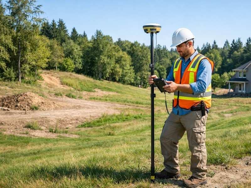
What Happens During a Topographic Survey
The fieldwork looks different from a boundary survey. The crew isn’t just finding corners and marking lines. They’re collecting elevation data at many points across the entire site.
Surveyors use total stations and GPS equipment to measure elevations at regular intervals and at key features like high points, low points, and grade changes. The more data collected, the more accurate the contour map will be. On a small residential lot, this might take a few hours. On a larger parcel with varied terrain, it can take a full day or more.
Once the field data is processed, the surveyor produces the finished map. Contour lines get drawn at consistent elevation intervals, usually one foot or two feet apart depending on the terrain and what the project needs. That map goes to the engineer or architect as the base for all design work.
What the Finished Survey Map Looks Like
The finished topographic survey is a drawing that a design professional can use directly. It typically includes:
- Property boundaries, if included in the scope
- Spot elevations at key points across the site
- Contour lines at the specified interval
- All mapped features labeled and located
- A legend, scale, and north arrow
- The surveyor’s certification and seal
This drawing becomes the base map for site plans, grading plans, drainage designs, and architectural layouts. It’s where engineering work on a new project starts.
Survey mapping at this level requires a licensed professional surveyor. The certification on the finished drawing confirms the data was collected and processed to professional standards.
Frequently Asked Questions
What is a topographic survey used for?
Engineers, architects, and builders use it to understand the shape of the land before designing a project. The elevation data and contour map guide decisions about building placement, drainage, grading, and earthwork.
How much does a topographic survey cost?
Costs typically range from $400 to $1,500 for a standard residential lot. Size, terrain, and the level of detail required all affect the price. Larger parcels or heavily wooded sites cost more. The article on land survey cost has a full breakdown of survey pricing by type.
Do I need a topographic survey to get a building permit?
It depends on your municipality and the scope of work. Some areas require topographic data as part of a permit application for grading, drainage, or new construction. Check with your local building or planning department before ordering.
How is a topographic survey different from a site plan?
A topographic survey records what currently exists on the ground. A site plan is a design document that shows what is being proposed. The site plan is usually drawn on top of the topographic survey as the base layer.
Can a topographic survey be done at the same time as a boundary survey?
Yes. Many survey firms offer both together. That’s often more efficient and cost-effective than ordering them separately. If your project needs both, ask about a combined scope when requesting a quote.
How long does a topographic survey take?
Fieldwork on a standard residential lot usually takes a few hours to a full day, depending on size and terrain. Processing and drafting the finished map adds several more business days. Most residential topographic surveys are completed within one to two weeks from the order date.