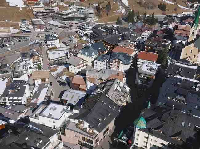
↓
 

Charlotte Land Surveyor

...a Pro17 Engineering marketing website.

Charlotte Land Surveyor
  • Home
  • ALTA Survey
  • Boundary Surveying
  • Construction Survey
  • Drone LiDAR Mapping
  • Elevation Certificate
  • Land Surveying
  • Lot Survey – Closing Survey
  • Topographic Survey
  • Blog
  • Contact Us
Home 1 2 3 … 7 8 >>

Post navigation

← Older posts

Welcome to Charlotte Land Surveyor

Charlotte Land Surveyor Posted on December 18, 2017 by Charlotte SurveyorFebruary 18, 2020

This site is intended to provide you with information on Land Surveying in the Charlotte, NC and Mecklenburg County area of North Carolina. If you’re looking for a Charlotte Land Surveyor, you’ve come to the right place. If you’d rather talk to someone about your land surveying needs, please call our local number at (704) 285-1222 today. For more information, please continue to read.

madison land surveyingLand Surveyors are professionals who make precise measurements to determine the size and boundaries of a piece of real estate.  While this is a simplistic definition, boundary surveying is one of the most common types of surveying related to home and land owners. If you fall into the following categories, please click on the appropriate link for more information on that subject:

Charlotte Land Surveyor services:

    1. I need to know where my property corners or property lines are. (Boundary Survey)
    2. I have a loan closing or re-finance coming up on my home in a subdivision. (Lot Survey)
    3. I need a map of my property with contour lines to show elevation differences for my architect or engineer. (Topo Survey)
    4. I’ve just been told I’m in a flood zone or I’ve been told I need an elevation certificate in order to obtain flood insurance or prove I don’t need it. (Flood Survey)
    5. I’m purchasing a lot/house in a recorded subdivision. (Lot Survey – See Boundary Survey)
    6. I’m purchasing a larger tract of land, acreage, that hasn’t been subdivided in the past. (Boundary Survey)

Contact Charlotte Land Surveyor TODAY at (704) 285-1222.

Posted in alta survey, boundary surveying, elevation certificate, flood survey, land surveying, land surveyor, lot survey, property survey, topographic survey | Tagged Charlotte AL Land Surveyor, Charlotte Land Surveyors, land surveyor

ALTA Survey Issues That Can Slow Down Commercial Closings

Charlotte Land Surveyor Posted on June 19, 2026 by CharlotteLandSurveyorJune 21, 2026
Professional reviewing plans at a commercial property during the ALTA survey and due diligence process before closing.

A commercial closing has a lot of moving parts, and an ALTA survey is one step that can throw off the whole schedule if something goes wrong. Many buyers and attorneys don’t pay much attention to the survey until it becomes a problem, and by that point, the closing date is already in trouble. Knowing what causes ALTA survey delays ahead of time gives everyone a better shot at staying on track.

Missing Title Commitment Documents Can Delay ALTA Survey Completion

Before a surveyor touches the property, they need the title commitment and its supporting documents. Those records show what easements, rights-of-way, and other recorded items need to appear on the survey. Without them, the surveyor can’t finish the job correctly.

When those documents come in late or incomplete, the surveyor has to stop work, wait for the missing pieces, and then go back and fix what was already done. That process eats up time fast. A 30-day escrow can lose a full week just from this kind of delay, and most people don’t notice until the closing date is right around the corner. The title company and the surveyor should be sharing documents at the very beginning of the due diligence period, not midway through when everyone is already behind.

Unrecorded Easements and Access Rights Can Create Last-Minute Questions

Not everything that affects a property shows up in the public record. Shared driveways, utility access agreements, and informal easements between old owners sometimes never got recorded properly, and the survey process is often when they finally come to light.

When that happens, attorneys need time to review what was found and figure out what it means for the deal. The title company also has to decide how to handle coverage before moving forward. None of this is anyone’s fault, but it takes time regardless, and older commercial properties that changed hands several times carry the most risk for this kind of surprise. If the closing date is already tight, any extra review time can push the schedule back.

Differences Between Existing Site Conditions and Public Records May Require Further Investigation

What’s physically on a property and what’s written in public records don’t always match. A building gets added, a parking lot gets expanded, or a utility line gets moved, and the paperwork never gets updated to reflect it. When a surveyor finds something on the ground that doesn’t line up with available records, that gap has to be explained before the survey can be wrapped up.

Lenders pay close attention to these situations. A structure that shows up on the survey but isn’t in any recorded document raises questions about permits and property boundaries, and those questions need answers before a lender approves anything. Getting those answers might mean more research, calls to local agencies, or another trip to the property, and each of those steps takes time. When this happens near the end of escrow, the closing date is usually what gets pushed back.

Table A Requests Added Late in the Process Can Extend Survey Timelines

An ALTA survey comes with a list of optional add-ons called Table A items. These can include things like flood zone details, building square footage, parking counts, and utility locations. The surveyor plans the fieldwork based on whatever Table A items everyone agrees on at the start.

Problems show up when someone adds new items after fieldwork has already started. A lender asks for utility locations after reviewing early drafts. An attorney realizes zoning information wasn’t requested. These changes seem small, but some of them mean the surveyor has to go back to the property or pull records that weren’t part of the original plan. That takes extra time, and in a commercial deal, extra time has a real cost. The best way to avoid this is simple: confirm the full Table A list with all parties before any fieldwork begins.

Why Waiting Until the End of Escrow to Order an ALTA Survey Creates Pressure

Most survey-related closing delays share a common starting point. Someone ordered the survey too late. It happens because other tasks felt more urgent, or because people assumed the survey would be quick and easy. By the time the surveyor finishes and sends over the results, there’s no time left to deal with anything unexpected without pushing the closing.

ALTA surveys on commercial properties take real time to complete. Scheduling can take several days on its own, and that’s before fieldwork, document review, or any follow-up work the findings might require. Ordering the survey in the first week of due diligence gives the team room to handle problems without a crisis. Ordering it in the final two weeks turns every finding into an emergency, and emergencies at closing are costly for everyone involved.

FAQs

What issues commonly delay an ALTA survey?
Missing title documents, unrecorded easements, gaps between site conditions and public records, and late Table A requests are the most common causes of delays.

Can an ALTA survey affect the closing date?
Yes. When survey findings need legal review or more documentation, the closing can get pushed back by days or more, depending on what turns up.

Why does a surveyor need the title commitment?
The title commitment shows recorded easements, rights-of-way, and other details that must appear on the survey. The surveyor can’t complete the work accurately without it.

Can additional Table A items delay the survey process?
Yes. Adding items after fieldwork has started may require a return visit to the property or more research, both of which add time.

When should an ALTA survey be ordered during a commercial transaction?
At the start of the due diligence period. Ordering early gives the team enough time to deal with any findings before the closing date becomes a hard deadline.

Posted in alta survey, land surveying | Tagged land survey

Why a Boundary Survey Matters Before Replacing an Old Fence

Charlotte Land Surveyor Posted on June 18, 2026 by CharlotteLandSurveyorJune 18, 2026
Land surveyors locating property boundaries near a residential fence before replacing an existing fence.

Replacing a fence feels like a simple home improvement project, but a boundary survey can be the one step that saves you from a costly mistake. Before you pull out old posts or sign a contract with a fence contractor, knowing exactly where your property line sits matters more than most homeowners expect.

Why Old Fence Locations Are Not Always Reliable

A fence that’s been standing for 20 or 30 years looks permanent, but its position on your lot might tell a different story. Previous owners sometimes installed fences based on guesswork, verbal agreements with neighbors, or rough estimates from an old survey. Original property markers, like iron pins or concrete monuments, can shift over time due to soil movement, lawn work, or simple neglect.

Here’s what that means for you today: the old fence line and the legal property line are often two different things. A few inches might not sound serious, but encroachments of even six inches can complicate a fence replacement project once a neighbor notices the new structure sits closer to their yard than before.

A boundary survey sends a licensed land surveyor to your property to locate the official corners and lines recorded in public land records. That’s the number you can actually build from with confidence.

How a Boundary Survey Helps Prevent Expensive Fence Reinstallation

Installing a new fence in the wrong location is an expensive lesson. If you place the fence over your neighbor’s property, even by accident, you may need to tear it down and rebuild it at your own cost. Depending on the material, that can mean losing thousands of dollars in labor and supplies.

A boundary survey done before construction gives you a verified starting point. Your fence contractor works from real coordinates instead of assuming the old fence was right. This small upfront investment can prevent you from paying twice for the same job, and it removes any guesswork from the process.

Concrete, brick, or vinyl privacy fencing costs far more than basic wood. The higher the project budget, the more a survey is worth the cost. Getting that line confirmed before a single post goes in the ground just makes financial sense.

Why Fence Replacement Projects Can Trigger New Property Questions

Neighbors who never said a word about the old fence may suddenly have opinions once they see a new one going up. That’s not unusual. An old, worn fence blends into the background. A brand-new fence draws attention, and with attention comes questions.

“Is that on the right line?” is a fair question, and one you should be able to answer. A boundary survey gives you documentation you can actually show. You’ll have a stamped survey map from a licensed professional that confirms where the fence sits relative to the legal boundary. That one document can resolve most neighbor concerns before they turn into disputes.

Without that paperwork, a disagreement over a few feet of fence line can escalate into something that costs far more to resolve than the survey ever would have.

Local Fence Rules and Setbacks Homeowners Should Understand

Most cities require fences to sit a certain distance from the property line, not directly on it. These are called setback requirements, and they vary depending on where you live, the type of fence you’re installing, and sometimes the zoning of your neighborhood.

HOAs add another layer. Some associations limit fence height, material, or style based on community rules that were agreed upon when the homes were built. Violating those rules, even unintentionally, can result in fines or forced removal.

Knowing your exact property line is the first step toward understanding how setback rules apply to your project. A boundary survey gives you that baseline. From there, you or your contractor can check local codes and HOA guidelines to confirm your fence plan is compliant before any work starts.

When It Makes Sense to Order a Boundary Survey Before Hiring a Fence Contractor

Not every fence replacement needs a full survey. Replacing a simple garden border on a well-established suburban lot with clear markers might not require one. But several situations make a survey worth scheduling before you call a contractor:

  • You’re replacing a shared fence with a neighbor and both parties want clarity on cost and placement
  • The old fence is visibly off-center or was installed without any record of where the property line sits
  • You’re upgrading to a masonry wall, vinyl privacy fence, or any higher-cost permanent structure
  • Your lot is irregular, corner-situated, or borders a public easement
  • You bought the property recently and haven’t verified the boundary locations yourself

These situations carry more risk than a basic like-for-like wood fence swap. A survey takes the uncertainty out of the project before it becomes a problem.

FAQs

Do I need a boundary survey to replace an existing fence?
A boundary survey isn’t always required, but it confirms the legal property line before a new fence goes in, which can prevent disputes and costly reinstallation.

Can I build a new fence where the old fence was located?
Not necessarily. An older fence may not have been placed on the actual boundary line, so the old position isn’t a reliable guide.

Will a boundary survey show where my new fence should go?
A boundary survey identifies the property boundaries and corner locations, which gives you the information needed to plan proper fence placement.

Can replacing a fence create disagreements with neighbors?
Yes. A new fence draws more attention than an old one, and questions about ownership or placement can come up even when the old fence never caused any issues.

Should I get a survey before hiring a fence contractor?
For shared fences, expensive upgrades, or uncertain property lines, getting a boundary survey before construction starts is generally the smarter call.

Posted in boundary surveying, land surveying | Tagged land survey

What a Topographic Survey Shows and When You Need One

Charlotte Land Surveyor Posted on June 18, 2026 by CharlotteLandSurveyorJune 11, 2026
Land surveyor conducting a topographic survey to map elevation changes across a residential property

A topographic survey doesn’t come up in most conversations until a project requires one. Then suddenly everyone involved needs one, and nobody is quite sure what it produces. If you’re a homeowner, a land buyer, or someone planning to build, this article explains what a topographic survey is, what it shows, and when you’d actually need one.

What a Topographic Survey Actually Produces

A boundary survey focuses on property lines. A topographic survey focuses on what the land itself looks like. The finished product is a detailed map. It shows elevation changes across the site, contour lines that reveal slopes and grades, and the locations of features already on the property.

Those features usually include:

  • Trees and large vegetation
  • Buildings, sheds, and retaining walls
  • Utility poles, boxes, and surface access points
  • Fences and walls
  • Drainage channels, streams, and low spots
  • Roads and paved areas

Everything gets plotted at specific elevations. That means whoever is designing the project knows exactly what’s on the ground and how the land rises and falls from one point to another.

The drawing looks two-dimensional, but it holds three-dimensional information. Every point on the map has an elevation attached to it. That’s what makes it useful for engineering and design.

How a Topographic Survey Differs From a Boundary Survey

These two surveys serve different purposes. A lot of people assume they do the same thing. They don’t.

A boundary survey answers one question: where does this property begin and end?

A topographic survey answers a different question: what does the land inside those boundaries actually look like?

Both can be done at the same time. But ordering one doesn’t give you the other. If you need confirmed property lines, that’s a boundary survey. If you need elevation and terrain data for a design project, that’s a topographic survey. Many projects end up needing both.

When a Topographic Survey Becomes Necessary

Not every property owner needs one. It usually comes up when a project involves changes to the land, or when a designer needs to understand the terrain before making decisions.

New construction on raw land. Before an architect or engineer designs a home on an undeveloped lot, they need to know what the land looks like. The topographic survey gives them elevation data to position the building, plan drainage, and avoid surprises once construction starts.

Home additions and site improvements. Adding a pool, a large deck, a garage, or a major grading project may require one. Engineers use the elevation data to make sure new structures drain properly and don’t push water toward the existing home or neighboring properties.

Land development and subdivision. Developers planning to build multiple structures or divide land almost always need a topographic survey. Civil engineers use it to design roads, drainage systems, utility layouts, and grading plans for the whole site.

Steep or uneven terrain. On lots with significant slopes, a topographic survey is often essential before design work can begin. Slopes affect foundation type, driveway grade, and where water goes during heavy rain. Good elevation data prevents bad decisions from making it into the plans.

Drainage problems on existing properties. Homeowners with standing water, erosion, or recurring wet spots sometimes order one to understand exactly how water moves across their property. That data helps engineers design a drainage fix that actually works with how the land naturally flows.

What Happens During a Topographic Survey

The fieldwork looks different from a boundary survey. The crew isn’t just finding corners and marking lines. They’re collecting elevation data at many points across the entire site.

Surveyors use total stations and GPS equipment to measure elevations at regular intervals and at key features like high points, low points, and grade changes. The more data collected, the more accurate the contour map will be. On a small residential lot, this might take a few hours. On a larger parcel with varied terrain, it can take a full day or more.

Once the field data is processed, the surveyor produces the finished map. Contour lines get drawn at consistent elevation intervals, usually one foot or two feet apart depending on the terrain and what the project needs. That map goes to the engineer or architect as the base for all design work.

What the Finished Survey Map Looks Like

The finished topographic survey is a drawing that a design professional can use directly. It typically includes:

  • Property boundaries, if included in the scope
  • Spot elevations at key points across the site
  • Contour lines at the specified interval
  • All mapped features labeled and located
  • A legend, scale, and north arrow
  • The surveyor’s certification and seal

This drawing becomes the base map for site plans, grading plans, drainage designs, and architectural layouts. It’s where engineering work on a new project starts.

Survey mapping at this level requires a licensed professional surveyor. The certification on the finished drawing confirms the data was collected and processed to professional standards.

Frequently Asked Questions

What is a topographic survey used for? 

Engineers, architects, and builders use it to understand the shape of the land before designing a project. The elevation data and contour map guide decisions about building placement, drainage, grading, and earthwork.

How much does a topographic survey cost? 

Costs typically range from $400 to $1,500 for a standard residential lot. Size, terrain, and the level of detail required all affect the price. Larger parcels or heavily wooded sites cost more. The article on land survey cost has a full breakdown of survey pricing by type.

Do I need a topographic survey to get a building permit? 

It depends on your municipality and the scope of work. Some areas require topographic data as part of a permit application for grading, drainage, or new construction. Check with your local building or planning department before ordering.

How is a topographic survey different from a site plan? 

A topographic survey records what currently exists on the ground. A site plan is a design document that shows what is being proposed. The site plan is usually drawn on top of the topographic survey as the base layer.

Can a topographic survey be done at the same time as a boundary survey? 

Yes. Many survey firms offer both together. That’s often more efficient and cost-effective than ordering them separately. If your project needs both, ask about a combined scope when requesting a quote.

How long does a topographic survey take? 

Fieldwork on a standard residential lot usually takes a few hours to a full day, depending on size and terrain. Processing and drafting the finished map adds several more business days. Most residential topographic surveys are completed within one to two weeks from the order date.

Posted in topographic survey | Tagged topographic survey

Post navigation

← Older posts

Search This Site

Get Quote Button

Recent Posts

  • ALTA Survey Issues That Can Slow Down Commercial Closings
  • Why a Boundary Survey Matters Before Replacing an Old Fence
  • What a Topographic Survey Shows and When You Need One
  • What Is an ALTA Survey and Who Actually Needs One?
  • Boundary Survey Cost: Prices and What Affects Them
© Copyright Charlotte Land Surveyor
Charlotte, NC
Phone:(704) 285-1222

Privacy Policy | Terms of Use

Web Development and SEO by:
N2Biz.co

Privacy Policy | Terms of Use

↑